Coastal systemsare complex and dynamic environments where land meets...
A Level Geography: Coastal Systems Notes and Exam Questions
CandyFloss OfDoom@candyflossofdoom


1 / 10
1
of 10
Understanding Coastal Systems and Landscapes in Geography
A coastal system represents a complex network of interconnected processes and features that shape our shorelines. In Coastal systems a level Geography, we examine how these dynamic environments function through various components and interactions.
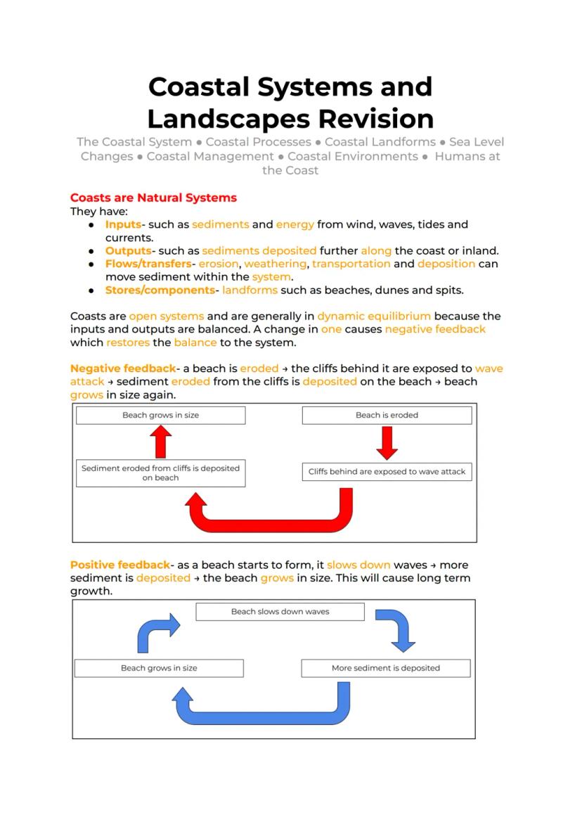
Coastal systems operate as open systems with continuous exchanges of energy and materials. The primary inputs include sediments from various sources and energy from wind, waves, tides, and currents. These systems maintain a dynamic equilibrium through negative feedback mechanisms, where changes in one component trigger responses that help restore balance.
Definition: A coastal system is an open system where inputs, outputs, transfers, and stores work together to shape and maintain coastal landscapes. The system extends 60km inland and 320km offshore.
The coastal zone consists of distinct regions, each playing a crucial role in coastal processes. The backshore extends from high water marks to dunes, while the foreshore lies between high and low water marks. The nearshore zone, where waves transform and break, is particularly active in sediment transport. Understanding these zones is essential for A level Geography coasts revision and coastal management strategies.
Highlight: Coastal systems demonstrate both negative and positive feedback loops. For example, when a beach erodes, exposed cliffs provide new sediment that rebuilds the beach, illustrating negative feedback that maintains system balance.
2
of 10
Energy Sources in Coastal Systems and Landscapes
The dynamic nature of coastal environments is powered by multiple energy sources that drive coastal processes. Wind, waves, and tides represent the primary forces shaping our coastlines, making them crucial topics in Coastal systems a level Geography.
Wind generates waves through friction with the water surface, creating circular motion in the water. Wave characteristics depend on three key factors: wind speed, duration, and fetch (distance over which wind blows). These factors determine whether waves will be constructive (building beaches) or destructive (eroding shorelines).
Example: Constructive waves occur 6-8 times per minute and have strong swash but weak backwash, depositing material on beaches. Destructive waves, occurring 10-14 times per minute, have powerful backwash that removes beach material.
Tidal influences, caused by gravitational forces of the moon and sun, create regular patterns of water level changes. Spring tides occur when sun and moon align, producing maximum tidal ranges, while neap tides result from perpendicular alignment, creating minimal tidal ranges. These patterns significantly influence coastal processes and landform development.
3
of 10
Coastal Currents and Energy Systems
Ocean currents play a vital role in coastal systems, transporting materials and energy along coastlines. These movements are fundamental to understanding Human interaction with coastal systems in geography.
Estuarine environments demonstrate complex current patterns where freshwater meets saltwater. Dense saltwater creates bottom currents flowing inland, while lighter freshwater flows seaward at the surface. This circulation pattern influences sediment transport and ecosystem development.
Vocabulary: Upwelling occurs when surface winds push warm water away from the coast, allowing nutrient-rich deep water to rise, creating productive fishing grounds.
Global ocean currents, like the Gulf Stream, distribute heat from equatorial regions toward the poles. These systems can be disrupted by climate changes, as demonstrated by historical events where freshwater influx altered current patterns and affected regional climates.
4
of 10
Coastal Energy Levels and Their Impact
Understanding energy levels in coastal systems is crucial for A level geography coastal systems notes aqa. Coasts are classified as high-energy or low-energy environments based on wave power and exposure to oceanic forces.
High-energy coasts experience powerful waves and significant erosion, typically featuring dramatic landforms like cliffs, caves, and stacks. These environments often result from strong winds, long fetches, and steeply shelving offshore zones.
Definition: Low-energy coasts receive gentler wave action and experience more deposition than erosion, often developing features like salt marshes and mudflats. They may be protected by natural barriers like coral reefs or islands.
The energy level of a coast determines its characteristic landforms and processes, making this understanding essential for coastal management and planning. This knowledge is particularly relevant for Human activities in coastal areas and their environmental impacts.
5
of 10
Understanding Sediment Sources and Coastal Systems
Coastal systems and landscapes a level Geography involves understanding how sediment moves through coastal environments. The primary sources of sediment in coastal systems a level Geography include riverine inputs, eroded cliff materials, marine organism remains, and offshore deposits.
Rivers serve as crucial conduits, transporting eroded inland sediment into coastal zones. When sea levels rise, river valleys can become submerged, forming estuaries that integrate into the broader coastal system. Wave action, weathering processes, and landslides contribute to cliff erosion, providing additional sediment input. Marine organisms also play a role through their shell remains, which eventually break down into sediment.
The concept of sediment budget is fundamental in A level Geography coasts revision. This represents the balance between sediment entering and leaving a coastal system. A positive budget occurs when input exceeds output, resulting in coastline expansion. Conversely, a negative budget leads to coastal retreat.
Definition: Littoral cells are distinct sections of coastline where erosion and deposition maintain a relative balance. These cells typically have natural boundaries like headlands and theoretically function as closed systems.
6
of 10
Coastal Processes and Erosion Mechanisms
In A level geography coastal systems notes aqa, understanding erosion processes is crucial. The six main erosional mechanisms are abrasion, hydraulic action, cavitation, wave quarrying a level Geography, corrosion, and attrition.
Abrasion occurs when wave-transported sediment impacts cliff faces, while hydraulic action involves the force of waves compressing air in rock cracks. Cavitation happens when compressed air expands violently, and wave quarrying directly detaches rock through wave energy. These processes work together to shape coastal landscapes.
Highlight: Transportation methods include suspension, saltation, and traction, with fluvial processes accounting for 95% of ocean sediment input.
The movement of sediment through Coastal systems a level Geography involves both marine and aeolian transport. Longshore drift represents a significant process where sediment moves parallel to the shore through the combined action of swash and backwash.
7
of 10
Weathering and Mass Movement in Coastal Systems
Human interaction with coastal systems in geography examples often intersects with natural weathering processes. Sub-aerial weathering, including crystallization, freeze-thaw cycles, and chemical weathering, significantly impacts coastal landscapes.
Mass movement represents a critical aspect of Coastal system definition Geography. Various types include rockfalls, landslides, rotational slumps, and mudflows. These processes are influenced by factors such as sediment cohesion, slope characteristics, and environmental conditions.
Example: The White Cliffs of Dover experienced a significant rockfall in March 2012, demonstrating how weathering processes can lead to dramatic coastal changes.
Understanding these processes is essential for A level Geography coasts exam questions and helps explain how Human activities in coastal areas can impact natural coastal systems.
8
of 10
Coastal Landscape Evolution and Human Impact
The interaction between natural processes and Human activities in coastal areas shapes coastal landscapes over time. Soil creep represents a gradual form of mass movement, particularly affecting unconsolidated materials like clay.
Environmental factors significantly influence coastal evolution. Heavy rainfall can saturate rock structures, reducing internal friction and increasing collapse risk. This understanding is crucial for AQA a level Geography coasts specification studies.
Vocabulary: Unconsolidated soils refer to loose materials with minimal particle cohesion, making them particularly vulnerable to erosion and movement.
These processes and their impacts form essential knowledge for Coastal systems and landscapes a level revision aqa, helping students understand both natural coastal evolution and human intervention effects.
9
of 10
Understanding Coastal Landforms and Formation Processes in Coastal Systems A Level Geography
The formation of coastal landforms represents a crucial topic in A Level Geography coasts revision. These distinctive features emerge through the complex interaction of geological structures and marine processes, creating two primary types of coastlines that produce varying landforms.
Concordant coastlines occur where rock formations run parallel to the shore, with harder rock bands protecting softer layers from erosion. This arrangement is prominently displayed along the UK's south coast, demonstrating how geological structure influences coastal development. In contrast, discordant coastlines feature rock bands running perpendicular to the shore, creating alternating strips of hard and soft rock, as seen along Ireland's western coast. This fundamental difference in rock orientation leads to distinctly different erosional patterns and resulting landforms.
Definition: A concordant coastline occurs when rock bands run parallel to the shore, while a discordant coastline has rock bands running perpendicular to the shore. These configurations significantly influence coastal landform development and are essential concepts in Coastal systems and landscapes a level Geography.
The formation of cliffs and wave-cut platforms represents one of the most dramatic examples of erosional processes in coastal environments. These features develop through the persistent action of waves and weathering processes at the base of coastal slopes. When waves create a notch at the high water mark, it can eventually develop into a cave. As this process continues, the unsupported rock above eventually collapses, leaving behind a characteristic wave-cut platform. This sequence of events is particularly well-demonstrated at locations like Lannacombe Bay in South Devon, providing excellent case studies for A level Geography coasts exam questions.
10
of 10
Advanced Coastal Landform Features and Formation Processes
The development of headlands and bays represents a complex interplay between rock resistance and marine erosion, making them crucial study elements for Coastal systems a level Geography. These features typically form along discordant coastlines, where differential erosion creates distinctive coastal profiles. The process begins when waves preferentially erode softer rock sections, forming bays, while more resistant rock remains as prominent headlands.
Example: The Cape of Good Hope in South Africa provides an excellent illustration of headland and bay formation, demonstrating how differential erosion shapes coastlines over time. This case study is frequently featured in AQA a Level Geography coasts Past papers.
A particularly interesting variation in coastal landform development is the formation of coves, which can occur when wave refraction processes modify bay shapes into more circular forms. This process can happen on concordant coastlines when water exploits weaknesses in resistant rock layers, accessing softer rock behind. The resulting feature, exemplified by Lulworth Cove, represents a distinct sediment cell within the larger coastal system.
The evolution of caves, arches, and stacks follows a sequential process beginning with the exploitation of rock weaknesses by hydraulic action. This process is intensified within the intertidal zone, where pressurized air forces cracks to widen. Various weathering processes, including salt crystallization and alternating wet-dry cycles, further contribute to the development of these features, particularly in chalk formations. These processes and resulting landforms are essential components of Coastal systems and landscapes a level revision aqa.
We thought you’d never ask...
Our AI Companion is a student-focused AI tool that offers more than just answers. Built on millions of Knowunity resources, it provides relevant information, personalised study plans, quizzes, and content directly in the chat, adapting to your individual learning journey.
You can download the app from Google Play Store and Apple App Store.
That's right! Enjoy free access to study content, connect with fellow students, and get instant help – all at your fingertips.
Similar content
Most popular content: External Processes
6Coastal Erosion Dynamics
Explore the processes of coastal erosion, including the formation of caves, arches, stacks, and wave cut platforms. This summary covers key concepts such as longshore drift, sediment movement, and coastal management strategies, specifically focusing on the Lyme Regis case study. Ideal for GCSE Geography students preparing for exams.
101906
Coastal Erosion Processes
Explore the intricate processes of coastal erosion, including hydraulic action, abrasion, and weathering. This summary covers key concepts such as wave cut platforms, headlands, and coastal management strategies. Ideal for AQA Geography students seeking to understand coastal landscapes and their dynamics.
101,24161
Understanding Beach Formation
Explore the intricate processes of beach formation and depositional landforms in coastal geography. This summary covers key concepts such as longshore drift, tombolos, spits, and the characteristics of different beach materials. Ideal for Geography students studying coastal landscapes and processes.
1270315
Coastal Dynamics Overview
Explore the dynamic processes of coastal systems, focusing on the littoral zone, wave types, sediment cells, and the impact of long-term and short-term changes. This summary covers key concepts such as erosion, deposition, sediment budgets, and dynamic equilibrium, essential for Edexcel A Level Geography students.
125495
Coastal Landform Processes
Explore the formation of various coastal landforms including swash and drift aligned beaches, wave cut platforms, and salt marshes. This summary provides detailed explanations and diagrams illustrating the processes of erosion, deposition, and sediment transport that shape our coastlines. Ideal for geography students studying coastal systems.
1249018
Coastal Erosion Dynamics
Explore the processes of coastal erosion and the formation of landforms such as headlands and bays. This summary covers key concepts including hydraulic action, abrasion, and mass movement, essential for GCSE Geography students. Understand how soft rocks and varying resistance contribute to coastal landscapes.
10932
Most popular content in Geography
9U
Urbanisation - AQA GCSE Geography
Some questions on key knowledge from the Urbanisation topic in GCSE Geography
98070
T
topic one- hazards flashcards set 1
Explore the fascinating world of geography with these flashcards covering diverse topics like continents, landmarks, and natural wonders. Enhance your knowledge and ace your exams!
114760
AQA GCSE Geography Paper 1 revision notes (excl. case studies)
Revision notes for the AQA GCSE Geography specification. Does not include case studies as they are selected by the school.
93,77286
I
Introduction to Natural Hazard Types
Identify the differences between geological and meteorological hazards and understand the factors affecting hazard risk.
S32880
E
Exploring Natural Hazards: Causes and Effects
Discover the primary causes and common effects of natural hazards such as tsunamis, volcanic eruptions, hurricanes, wildfires, droughts, landslides, and more!
113240
P
Paper 1? Down what else
Explore the fascinating world of geography with these flashcards covering diverse topics like continents, landmarks, and natural wonders. Enhance your knowledge and ace your exams!
114792
I
Introduction to Global Urbanisation Concepts
Define urbanisation, explore rural-to-urban migration, and identify the push and pull factors driving global city growth.
112210
Geography Hazards & Landscapes
Explore key concepts in AQA Geography, covering rivers, coasts, natural hazards, and ecosystems. This summary highlights essential topics such as river processes, coastal management, desertification, and case studies on earthquakes and tropical storms. Ideal for exam preparation and understanding geographical systems.
103,064117
Geography Edexcel B: Conservation & Energy
Explore comprehensive notes for Edexcel B Geography Paper 3, covering critical topics such as deforestation, sustainable forestry, energy consumption, and the impact of human activities on the biosphere. This resource is essential for understanding the challenges and strategies in global conservation efforts.
103,62894
Most popular content
9Sociology of Education Overview
Explore comprehensive A-Level Sociology notes on the education system, covering key theories, policies, and sociological perspectives. This resource includes insights on marketisation, gender roles, cultural deprivation, and educational inequalities, providing a thorough understanding of how education shapes social stratification and individual achievement. Ideal for exam preparation and in-depth study.
12102,8983,041
Sociology of Families: Comprehensive Revision
Dive into an extensive overview of family dynamics, perspectives, and patterns in sociology. This resource covers key concepts such as family diversity, gender roles, marriage, and the impact of social policies on family structures. Perfect for A-Level Sociology students preparing for Paper 2.
1273,6912,307
Criminology: Crime & Punishment Overview
Comprehensive mindmaps covering key concepts in the Crime and Punishment topic for WJEC Criminology Unit 4. This resource includes detailed insights into the Criminal Justice System, crime prevention strategies, sentencing models, and the roles of various agencies. Ideal for A-Level revision, ensuring you grasp essential theories and legislative processes to excel in your exams.
1254,8781,059
Comprehensive Crime & Deviance Overview
Explore an extensive revision of crime and deviance topics, including theories, types of crime, and the impact of media. This resource covers key concepts such as Marxism, functionalism, gender and crime, and the influence of globalization on criminal behavior. Ideal for students seeking a thorough understanding of criminology and its various theories. Type: Full Topic Revision.
1251,6621,399
C
Cell Biology and Cell structure
cell structures
93,2590
WJEC Unit 4 Criminology
Criminology unit 4 detailed revision note
127,159125
An Inspector Calls: Character Insights
Explore in-depth analysis and key quotes for characters in J.B. Priestley's 'An Inspector Calls'. This resource covers Gerald Croft, Inspector Goole, Sheila Birling, Mrs. Birling, Eric Birling, and Eva Smith, focusing on themes of class, gender roles, and social responsibility. Ideal for students aiming for Grade 8 and above.
1025,437907
Criminology Theories Overview
Explore key criminology theories and their implications on crime and deviance. This comprehensive summary covers biological, psychological, and sociological perspectives, including labelling theory, right realism, and the impact of social campaigns on policy development. Ideal for A-Level criminology students seeking to understand the complexities of criminal behaviour and the factors influencing crime prevention strategies.
129,765210
Sociological Theories Overview
Comprehensive revision of key sociological theories including Functionalism, Marxism, Feminism, and Interpretivism. Explore concepts like value freedom, identity formation, and the critique of social control. Ideal for AQA A-Level Sociology students preparing for exams. This summary covers essential theories and their implications in sociology, providing a clear understanding of each perspective.
1231,466846
Students love us — and so will you.
4.6/5App Store
4.7/5Google Play
The app is very easy to use and well designed. I have found everything I was looking for so far and have been able to learn a lot from the presentations! I will definitely use the app for a class assignment! And of course it also helps a lot as an inspiration.
Stefan SiOS user
This app is really great. There are so many study notes and help [...]. My problem subject is French, for example, and the app has so many options for help. Thanks to this app, I have improved my French. I would recommend it to anyone.
Samantha KlichAndroid user
Wow, I am really amazed. I just tried the app because I've seen it advertised many times and was absolutely stunned. This app is THE HELP you want for school and above all, it offers so many things, such as workouts and fact sheets, which have been VERY helpful to me personally.
AnnaiOS user
A Level Geography: Coastal Systems Notes and Exam Questions
CandyFloss OfDoom@candyflossofdoom
Coastal systems are complex and dynamic environments where land meets sea, involving intricate interactions between waves, tides, and sediment movement.
Key aspects of Coastal systems and landscapes include:
- Wave processes including refraction, reflection, and longshore drift
- Erosional landforms like caves,...
1
of 10
Sign up to see the content. It's free!
- Access to all documents
- Improve your grades
- Join milions of students
By signing up you accept Terms of Service and Privacy Policy
Understanding Coastal Systems and Landscapes in Geography
A coastal system represents a complex network of interconnected processes and features that shape our shorelines. In Coastal systems a level Geography, we examine how these dynamic environments function through various components and interactions.
Coastal systems operate as open systems with continuous exchanges of energy and materials. The primary inputs include sediments from various sources and energy from wind, waves, tides, and currents. These systems maintain a dynamic equilibrium through negative feedback mechanisms, where changes in one component trigger responses that help restore balance.
Definition: A coastal system is an open system where inputs, outputs, transfers, and stores work together to shape and maintain coastal landscapes. The system extends 60km inland and 320km offshore.
The coastal zone consists of distinct regions, each playing a crucial role in coastal processes. The backshore extends from high water marks to dunes, while the foreshore lies between high and low water marks. The nearshore zone, where waves transform and break, is particularly active in sediment transport. Understanding these zones is essential for A level Geography coasts revision and coastal management strategies.
Highlight: Coastal systems demonstrate both negative and positive feedback loops. For example, when a beach erodes, exposed cliffs provide new sediment that rebuilds the beach, illustrating negative feedback that maintains system balance.
2
of 10Sign up to see the content. It's free!
- Access to all documents
- Improve your grades
- Join milions of students
By signing up you accept Terms of Service and Privacy Policy
Energy Sources in Coastal Systems and Landscapes
The dynamic nature of coastal environments is powered by multiple energy sources that drive coastal processes. Wind, waves, and tides represent the primary forces shaping our coastlines, making them crucial topics in Coastal systems a level Geography.
Wind generates waves through friction with the water surface, creating circular motion in the water. Wave characteristics depend on three key factors: wind speed, duration, and fetch (distance over which wind blows). These factors determine whether waves will be constructive (building beaches) or destructive (eroding shorelines).
Example: Constructive waves occur 6-8 times per minute and have strong swash but weak backwash, depositing material on beaches. Destructive waves, occurring 10-14 times per minute, have powerful backwash that removes beach material.
Tidal influences, caused by gravitational forces of the moon and sun, create regular patterns of water level changes. Spring tides occur when sun and moon align, producing maximum tidal ranges, while neap tides result from perpendicular alignment, creating minimal tidal ranges. These patterns significantly influence coastal processes and landform development.
3
of 10Sign up to see the content. It's free!
- Access to all documents
- Improve your grades
- Join milions of students
By signing up you accept Terms of Service and Privacy Policy
Coastal Currents and Energy Systems
Ocean currents play a vital role in coastal systems, transporting materials and energy along coastlines. These movements are fundamental to understanding Human interaction with coastal systems in geography.
Estuarine environments demonstrate complex current patterns where freshwater meets saltwater. Dense saltwater creates bottom currents flowing inland, while lighter freshwater flows seaward at the surface. This circulation pattern influences sediment transport and ecosystem development.
Vocabulary: Upwelling occurs when surface winds push warm water away from the coast, allowing nutrient-rich deep water to rise, creating productive fishing grounds.
Global ocean currents, like the Gulf Stream, distribute heat from equatorial regions toward the poles. These systems can be disrupted by climate changes, as demonstrated by historical events where freshwater influx altered current patterns and affected regional climates.
4
of 10Sign up to see the content. It's free!
- Access to all documents
- Improve your grades
- Join milions of students
By signing up you accept Terms of Service and Privacy Policy
Coastal Energy Levels and Their Impact
Understanding energy levels in coastal systems is crucial for A level geography coastal systems notes aqa. Coasts are classified as high-energy or low-energy environments based on wave power and exposure to oceanic forces.
High-energy coasts experience powerful waves and significant erosion, typically featuring dramatic landforms like cliffs, caves, and stacks. These environments often result from strong winds, long fetches, and steeply shelving offshore zones.
Definition: Low-energy coasts receive gentler wave action and experience more deposition than erosion, often developing features like salt marshes and mudflats. They may be protected by natural barriers like coral reefs or islands.
The energy level of a coast determines its characteristic landforms and processes, making this understanding essential for coastal management and planning. This knowledge is particularly relevant for Human activities in coastal areas and their environmental impacts.
5
of 10Sign up to see the content. It's free!
- Access to all documents
- Improve your grades
- Join milions of students
By signing up you accept Terms of Service and Privacy Policy
Understanding Sediment Sources and Coastal Systems
Coastal systems and landscapes a level Geography involves understanding how sediment moves through coastal environments. The primary sources of sediment in coastal systems a level Geography include riverine inputs, eroded cliff materials, marine organism remains, and offshore deposits.
Rivers serve as crucial conduits, transporting eroded inland sediment into coastal zones. When sea levels rise, river valleys can become submerged, forming estuaries that integrate into the broader coastal system. Wave action, weathering processes, and landslides contribute to cliff erosion, providing additional sediment input. Marine organisms also play a role through their shell remains, which eventually break down into sediment.
The concept of sediment budget is fundamental in A level Geography coasts revision. This represents the balance between sediment entering and leaving a coastal system. A positive budget occurs when input exceeds output, resulting in coastline expansion. Conversely, a negative budget leads to coastal retreat.
Definition: Littoral cells are distinct sections of coastline where erosion and deposition maintain a relative balance. These cells typically have natural boundaries like headlands and theoretically function as closed systems.
6
of 10Sign up to see the content. It's free!
- Access to all documents
- Improve your grades
- Join milions of students
By signing up you accept Terms of Service and Privacy Policy
Coastal Processes and Erosion Mechanisms
In A level geography coastal systems notes aqa, understanding erosion processes is crucial. The six main erosional mechanisms are abrasion, hydraulic action, cavitation, wave quarrying a level Geography, corrosion, and attrition.
Abrasion occurs when wave-transported sediment impacts cliff faces, while hydraulic action involves the force of waves compressing air in rock cracks. Cavitation happens when compressed air expands violently, and wave quarrying directly detaches rock through wave energy. These processes work together to shape coastal landscapes.
Highlight: Transportation methods include suspension, saltation, and traction, with fluvial processes accounting for 95% of ocean sediment input.
The movement of sediment through Coastal systems a level Geography involves both marine and aeolian transport. Longshore drift represents a significant process where sediment moves parallel to the shore through the combined action of swash and backwash.
7
of 10Sign up to see the content. It's free!
- Access to all documents
- Improve your grades
- Join milions of students
By signing up you accept Terms of Service and Privacy Policy
Weathering and Mass Movement in Coastal Systems
Human interaction with coastal systems in geography examples often intersects with natural weathering processes. Sub-aerial weathering, including crystallization, freeze-thaw cycles, and chemical weathering, significantly impacts coastal landscapes.
Mass movement represents a critical aspect of Coastal system definition Geography. Various types include rockfalls, landslides, rotational slumps, and mudflows. These processes are influenced by factors such as sediment cohesion, slope characteristics, and environmental conditions.
Example: The White Cliffs of Dover experienced a significant rockfall in March 2012, demonstrating how weathering processes can lead to dramatic coastal changes.
Understanding these processes is essential for A level Geography coasts exam questions and helps explain how Human activities in coastal areas can impact natural coastal systems.
8
of 10Sign up to see the content. It's free!
- Access to all documents
- Improve your grades
- Join milions of students
By signing up you accept Terms of Service and Privacy Policy
Coastal Landscape Evolution and Human Impact
The interaction between natural processes and Human activities in coastal areas shapes coastal landscapes over time. Soil creep represents a gradual form of mass movement, particularly affecting unconsolidated materials like clay.
Environmental factors significantly influence coastal evolution. Heavy rainfall can saturate rock structures, reducing internal friction and increasing collapse risk. This understanding is crucial for AQA a level Geography coasts specification studies.
Vocabulary: Unconsolidated soils refer to loose materials with minimal particle cohesion, making them particularly vulnerable to erosion and movement.
These processes and their impacts form essential knowledge for Coastal systems and landscapes a level revision aqa, helping students understand both natural coastal evolution and human intervention effects.
9
of 10Sign up to see the content. It's free!
- Access to all documents
- Improve your grades
- Join milions of students
By signing up you accept Terms of Service and Privacy Policy
Understanding Coastal Landforms and Formation Processes in Coastal Systems A Level Geography
The formation of coastal landforms represents a crucial topic in A Level Geography coasts revision. These distinctive features emerge through the complex interaction of geological structures and marine processes, creating two primary types of coastlines that produce varying landforms.
Concordant coastlines occur where rock formations run parallel to the shore, with harder rock bands protecting softer layers from erosion. This arrangement is prominently displayed along the UK's south coast, demonstrating how geological structure influences coastal development. In contrast, discordant coastlines feature rock bands running perpendicular to the shore, creating alternating strips of hard and soft rock, as seen along Ireland's western coast. This fundamental difference in rock orientation leads to distinctly different erosional patterns and resulting landforms.
Definition: A concordant coastline occurs when rock bands run parallel to the shore, while a discordant coastline has rock bands running perpendicular to the shore. These configurations significantly influence coastal landform development and are essential concepts in Coastal systems and landscapes a level Geography.
The formation of cliffs and wave-cut platforms represents one of the most dramatic examples of erosional processes in coastal environments. These features develop through the persistent action of waves and weathering processes at the base of coastal slopes. When waves create a notch at the high water mark, it can eventually develop into a cave. As this process continues, the unsupported rock above eventually collapses, leaving behind a characteristic wave-cut platform. This sequence of events is particularly well-demonstrated at locations like Lannacombe Bay in South Devon, providing excellent case studies for A level Geography coasts exam questions.
10
of 10Sign up to see the content. It's free!
- Access to all documents
- Improve your grades
- Join milions of students
By signing up you accept Terms of Service and Privacy Policy
Advanced Coastal Landform Features and Formation Processes
The development of headlands and bays represents a complex interplay between rock resistance and marine erosion, making them crucial study elements for Coastal systems a level Geography. These features typically form along discordant coastlines, where differential erosion creates distinctive coastal profiles. The process begins when waves preferentially erode softer rock sections, forming bays, while more resistant rock remains as prominent headlands.
Example: The Cape of Good Hope in South Africa provides an excellent illustration of headland and bay formation, demonstrating how differential erosion shapes coastlines over time. This case study is frequently featured in AQA a Level Geography coasts Past papers.
A particularly interesting variation in coastal landform development is the formation of coves, which can occur when wave refraction processes modify bay shapes into more circular forms. This process can happen on concordant coastlines when water exploits weaknesses in resistant rock layers, accessing softer rock behind. The resulting feature, exemplified by Lulworth Cove, represents a distinct sediment cell within the larger coastal system.
The evolution of caves, arches, and stacks follows a sequential process beginning with the exploitation of rock weaknesses by hydraulic action. This process is intensified within the intertidal zone, where pressurized air forces cracks to widen. Various weathering processes, including salt crystallization and alternating wet-dry cycles, further contribute to the development of these features, particularly in chalk formations. These processes and resulting landforms are essential components of Coastal systems and landscapes a level revision aqa.
We thought you’d never ask...
Our AI Companion is a student-focused AI tool that offers more than just answers. Built on millions of Knowunity resources, it provides relevant information, personalised study plans, quizzes, and content directly in the chat, adapting to your individual learning journey.
You can download the app from Google Play Store and Apple App Store.
That's right! Enjoy free access to study content, connect with fellow students, and get instant help – all at your fingertips.
Similar content
Most popular content: External Processes
6Coastal Erosion Dynamics
Explore the processes of coastal erosion, including the formation of caves, arches, stacks, and wave cut platforms. This summary covers key concepts such as longshore drift, sediment movement, and coastal management strategies, specifically focusing on the Lyme Regis case study. Ideal for GCSE Geography students preparing for exams.
101906
Coastal Erosion Processes
Explore the intricate processes of coastal erosion, including hydraulic action, abrasion, and weathering. This summary covers key concepts such as wave cut platforms, headlands, and coastal management strategies. Ideal for AQA Geography students seeking to understand coastal landscapes and their dynamics.
101,24161
Understanding Beach Formation
Explore the intricate processes of beach formation and depositional landforms in coastal geography. This summary covers key concepts such as longshore drift, tombolos, spits, and the characteristics of different beach materials. Ideal for Geography students studying coastal landscapes and processes.
1270315
Coastal Dynamics Overview
Explore the dynamic processes of coastal systems, focusing on the littoral zone, wave types, sediment cells, and the impact of long-term and short-term changes. This summary covers key concepts such as erosion, deposition, sediment budgets, and dynamic equilibrium, essential for Edexcel A Level Geography students.
125495
Coastal Landform Processes
Explore the formation of various coastal landforms including swash and drift aligned beaches, wave cut platforms, and salt marshes. This summary provides detailed explanations and diagrams illustrating the processes of erosion, deposition, and sediment transport that shape our coastlines. Ideal for geography students studying coastal systems.
1249018
Coastal Erosion Dynamics
Explore the processes of coastal erosion and the formation of landforms such as headlands and bays. This summary covers key concepts including hydraulic action, abrasion, and mass movement, essential for GCSE Geography students. Understand how soft rocks and varying resistance contribute to coastal landscapes.
10932
Most popular content in Geography
9U
Urbanisation - AQA GCSE Geography
Some questions on key knowledge from the Urbanisation topic in GCSE Geography
98070
T
topic one- hazards flashcards set 1
Explore the fascinating world of geography with these flashcards covering diverse topics like continents, landmarks, and natural wonders. Enhance your knowledge and ace your exams!
114760
AQA GCSE Geography Paper 1 revision notes (excl. case studies)
Revision notes for the AQA GCSE Geography specification. Does not include case studies as they are selected by the school.
93,77286
I
Introduction to Natural Hazard Types
Identify the differences between geological and meteorological hazards and understand the factors affecting hazard risk.
S32880
E
Exploring Natural Hazards: Causes and Effects
Discover the primary causes and common effects of natural hazards such as tsunamis, volcanic eruptions, hurricanes, wildfires, droughts, landslides, and more!
113240
P
Paper 1? Down what else
Explore the fascinating world of geography with these flashcards covering diverse topics like continents, landmarks, and natural wonders. Enhance your knowledge and ace your exams!
114792
I
Introduction to Global Urbanisation Concepts
Define urbanisation, explore rural-to-urban migration, and identify the push and pull factors driving global city growth.
112210
Geography Hazards & Landscapes
Explore key concepts in AQA Geography, covering rivers, coasts, natural hazards, and ecosystems. This summary highlights essential topics such as river processes, coastal management, desertification, and case studies on earthquakes and tropical storms. Ideal for exam preparation and understanding geographical systems.
103,064117
Geography Edexcel B: Conservation & Energy
Explore comprehensive notes for Edexcel B Geography Paper 3, covering critical topics such as deforestation, sustainable forestry, energy consumption, and the impact of human activities on the biosphere. This resource is essential for understanding the challenges and strategies in global conservation efforts.
103,62894
Most popular content
9Sociology of Education Overview
Explore comprehensive A-Level Sociology notes on the education system, covering key theories, policies, and sociological perspectives. This resource includes insights on marketisation, gender roles, cultural deprivation, and educational inequalities, providing a thorough understanding of how education shapes social stratification and individual achievement. Ideal for exam preparation and in-depth study.
12102,8983,041
Sociology of Families: Comprehensive Revision
Dive into an extensive overview of family dynamics, perspectives, and patterns in sociology. This resource covers key concepts such as family diversity, gender roles, marriage, and the impact of social policies on family structures. Perfect for A-Level Sociology students preparing for Paper 2.
1273,6912,307
Criminology: Crime & Punishment Overview
Comprehensive mindmaps covering key concepts in the Crime and Punishment topic for WJEC Criminology Unit 4. This resource includes detailed insights into the Criminal Justice System, crime prevention strategies, sentencing models, and the roles of various agencies. Ideal for A-Level revision, ensuring you grasp essential theories and legislative processes to excel in your exams.
1254,8781,059
Comprehensive Crime & Deviance Overview
Explore an extensive revision of crime and deviance topics, including theories, types of crime, and the impact of media. This resource covers key concepts such as Marxism, functionalism, gender and crime, and the influence of globalization on criminal behavior. Ideal for students seeking a thorough understanding of criminology and its various theories. Type: Full Topic Revision.
1251,6621,399
C
Cell Biology and Cell structure
cell structures
93,2590
WJEC Unit 4 Criminology
Criminology unit 4 detailed revision note
127,159125
An Inspector Calls: Character Insights
Explore in-depth analysis and key quotes for characters in J.B. Priestley's 'An Inspector Calls'. This resource covers Gerald Croft, Inspector Goole, Sheila Birling, Mrs. Birling, Eric Birling, and Eva Smith, focusing on themes of class, gender roles, and social responsibility. Ideal for students aiming for Grade 8 and above.
1025,437907
Criminology Theories Overview
Explore key criminology theories and their implications on crime and deviance. This comprehensive summary covers biological, psychological, and sociological perspectives, including labelling theory, right realism, and the impact of social campaigns on policy development. Ideal for A-Level criminology students seeking to understand the complexities of criminal behaviour and the factors influencing crime prevention strategies.
129,765210
Sociological Theories Overview
Comprehensive revision of key sociological theories including Functionalism, Marxism, Feminism, and Interpretivism. Explore concepts like value freedom, identity formation, and the critique of social control. Ideal for AQA A-Level Sociology students preparing for exams. This summary covers essential theories and their implications in sociology, providing a clear understanding of each perspective.
1231,466846
Students love us — and so will you.
4.6/5App Store
4.7/5Google Play
The app is very easy to use and well designed. I have found everything I was looking for so far and have been able to learn a lot from the presentations! I will definitely use the app for a class assignment! And of course it also helps a lot as an inspiration.
Stefan SiOS user
This app is really great. There are so many study notes and help [...]. My problem subject is French, for example, and the app has so many options for help. Thanks to this app, I have improved my French. I would recommend it to anyone.
Samantha KlichAndroid user
Wow, I am really amazed. I just tried the app because I've seen it advertised many times and was absolutely stunned. This app is THE HELP you want for school and above all, it offers so many things, such as workouts and fact sheets, which have been VERY helpful to me personally.
AnnaiOS user